Outsiders Utah is a fantastic resource powered by the OHV (Off-Highway Vehicle) community, designed to give riders confidence to explore Utah’s less-traveled trails. It’s part of the Trail 360 Project, a collaborative effort between the Utah OHV Program, local communities, and outdoor enthusiasts.
Key Features:
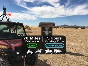
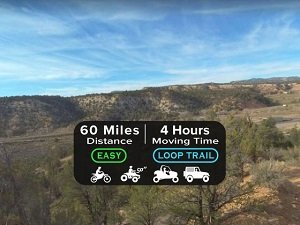
- Detailed Trail Listings: Entries include trail length, estimated time, difficulty level (Easy, Medium, Difficult), type (loop or out-and-back), permissible vehicle types (dirt bike, 50″ machine, side-by-side, full-size), plus terrain notes.
- Visual Previews: Trail segments include time-lapse video, Google Street View, and GPS overlays—letting you “see the trail before you ride it.”
- Extensive Trail Database: Sortable filters by region (Northern, Central, Southern, Southeast, Southwest Utah), vehicle type, difficulty, and trail length. Some trail examples: Poverty Flats, Moquith, and Four Mile to Kanab Creek.
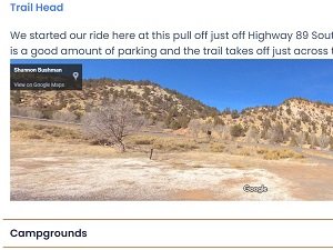
- Local Insights: Includes area info like nearby lodging, fuel stops, services, trailhead parking, and emergency contacts—great for trip planning.
- Downloads & Maps: Provides GPX/KML downloads compatible with Gaia, OnX, or in-vehicle GPS. Additional map tools include Flyover, street-view, and point-of-interest overlays.
Why Use Outsiders Utah?
Tech-Friendly Trip Tools
Download paths directly to your GPS or mapping app for seamless offline use..
Build Confidence in Exploration
See the trail visually before arrival—manage expectations on terrain and access challenges.
Discover Hidden Trails
Easily find lesser-known routes across Utah that match your vehicle type and skill level.
Customize Planning with Local Resources
Supports seamless navigation, comfort stops, and emergency access—all in one place.